
|
|
Study, work or travel in the UK. British
culture and life.
|
|
||
|
|
|
|
||
 |
||||
|
|
|
|||
 |
||||
|
A guide to Canterbury
|
||||
|
Sections:
|
Summary |
 |
| Facts & figures | ||
| Features | ||
| Environment | ||
| Entertainment | ||
| Transport | ||
| Further information | ||
| Links |
 |
The
Cathedral and City of Canterbury |
 |
Canterbury
& Kent (picture book) Photographer: Geraint Tellem Publisher: Jarrold Publishing Date: April 2002 |
| Canterbury
Photomap (aerial photo of town with street names added) Publisher: Overview Mapping Date: September 2001 |
 |
A-Z
Street Atlas of Margate and Ramsgate, Canterbury & Whitstable (street map) Publisher: Geographers' A-Z Map Company Date: December 2001 |
| Subject | Name |
| Population: | 45,700 (over 60 years old: 20.2%) |
| Region: | Kent, in South-East England |
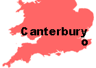
| Location: | See: map |
| Visiting from abroad:: | (see: Travel/Transport/Air) |
| Visiting from London: | 90 kilometres east of London |
| By train: 1 hour 30 minutes from Charing Cross or Victoria station. Cheap Day Return ticket (off-peak) with Young Person's Railcard (2002): £10.75 | |
| By coach: 1 hour 50 minutes from Victoria Coach Station | |
| Tourism: | A very popular tourist location |
| Language schools: | 6 schools which are recognised by the British Council (2002) |
The town contains many gardens (eg Westgate Gardens / Dane John Gardens), as well as the cathedral grounds
A safe atmosphere.
In 2001/02 there were 6.9 offences of violence against people per 1,000 people,
much lower than the English average of 10.8.
In 2000, Canterbury was ranked the 165th most deprived out of the 354 districts
in England.
Quite expensive accommodation
Back to top
Bus: Bus services are limited, especially at night
Car:
Train: There are two train stations (Canterbury West and Canterbury East)
close to the centre of town
Bicycle:
Walking: Easy to get around the town on foot. The central area has been
pedestrianised, but can be full of tourists in July and August
|
|
|